Look up and enjoy the clouds

They can add to some picture-perfect moments in the preserves

|  Story by Meghan McMahon |

7/16/2021

Depending on the day, clouds can be a blessing or a curse.

Clouds, of course, are what deliver the precipitation all life on Earth depends on. And they also make us more comfortable. On a hot day, a large cloud temporarily blocking the sun is as welcome as a cool drink of water. In the winter, a layer of clouds can insulate us, preventing temperatures from dropping.

They add beauty to the world, too. Have you ever seen a breathtaking sunrise or sunset without a cloud in the sky? Probably not, because the clouds are what add the lovely array of colors to these picture-perfect moments.

Sometimes, clouds simply bring us joy. Who hasn’t spent time simply watching the clouds roll by? Or looking for fun shapes hidden within these giant puffballs?

But what is a cloud really? Essentially, clouds are masses of ice crystals or water droplets that are suspended in the sky, according to NASA. Clouds form when air in the sky becomes cooler, causing the water vapor to condense into liquid form.

All clouds contain water vapor, but not all clouds produce rain. Rain occurs when water droplets join together to form larger droplets. When the droplets become large enough, gravity causes them to fall to the ground in the form of rain or, when it’s cold enough, snow, sleet or freezing rain, NASA reports.

On some days, there’s not a cloud in the sky, and that’s a result of the weather too. When an area is experiencing a high-pressure system, air sinks slowly and the air pressure begins to rise, according to the National Weather Service. When this happens, the air warms and there is no condensation that would cause clouds to form.

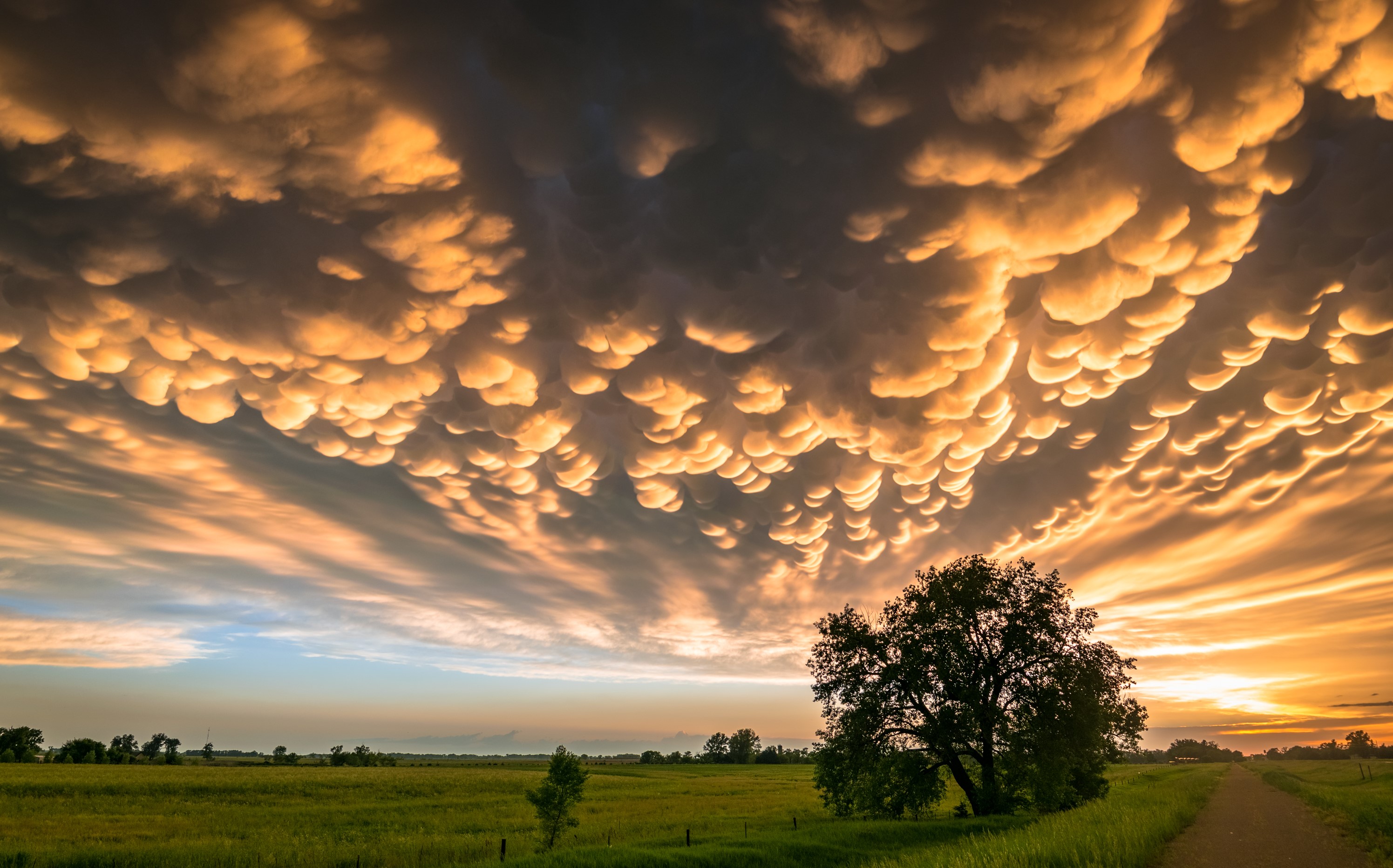
When we do see clouds in the sky, they can have many different shapes and appearances. Some are dark and ominous, others are thin and wispy. Still others are big and fluffy. There are 10 main types of clouds, and they are classified by their elevation and their shape and structure, according to the National Oceanic Atmospheric Administration. Based on elevation, clouds are classified as high, mid-level or low. High clouds are 16,500 feet to 45,000 feet above the ground, while mid-level clouds are 6,500 feet to 23,000 feet above ground and low clouds are less than 6,500 feet above ground.

When it comes to the many different kinds of clouds, you may notice that some of the same root words are included in many clouds’ names. That’s because in the early 1800s, an amateur meteorologist named Luke Howard proposed a naming convention for clouds that is the foundation of the classifications that are still used today, according to the National Weather Service. Howard recognized four cloud types and named them using Latin words:

  • Cumulus: Heaped or in a pile
  • Stratus: In a layer or sheet
  • Cirrus: Hairy, curled or thread-like
  • Nimbus: Bearing rain

Here is a closer look at the many different types of clouds that add dimension to the sky.

High clouds

Cirrocumulus clouds.

Cirrocumulus clouds (Photo via Shutterstock)

The highest clouds are typically thin, wispy clouds that look like streaks in the sky. They are not usually thick or dense enough to block out the sun. There are three kinds of these high clouds: cirrus, cirrocumulus and cirrostratus clouds.

The thinnest and patchiest of the high clouds is the cirrus clouds, which usually look like small patches or narrow bands, according to the National Weather Service. Cirrus clouds often are red or yellow in color just before sunrise or just after sunset. Because of how light filters through, they light up before other clouds do and the color will fade from them later. Even during the day, cirrus clouds near the horizon may have a golden yellow color.

Cirrocumulus clouds are also thin enough for the sun to shine through, but they often look like long rows or thin, rounded puffs. They are usually a bright white, but they can sometimes look gray in the sky, according to the National Center for Atmospheric Research. These clouds are most common in winter and are a sign of cold, fair weather.

Cirrostratus clouds are thin sheets of clouds that usually blanket the entire sky, but they aren’t thick enough to block the sun or even the moon from shining through. These clouds often signal a change in weather, because they usually appear about 12 hours to 24 hours before rain or a snowstorm, according to the center for atmospheric research.

Mid-level clouds

Altocumulus clouds.

Altocumulus clouds (Photo via Shutterstock)

Mid-level clouds mainly consist of water droplets or, when it is cold enough, ice particles. Altocumulus clouds are puffy, and they typically appear in clumps or layers. They are usually darker in some parts than others, according to the National Center for Atmospheric Research. These are the most common of the mid-level clouds, and often there may be several levels of them at different elevations, or they may appear in the sky with other kinds of clouds.

Altostratus form sheets or layers that blanket the entire sky. Sometimes the layers will be thin enough that the sun appears faintly behind them, but they can also sometimes reach higher up into the sky, as high as the high-level clouds, the weather service reports.

Like altostratus clouds, nimbostratus clouds can also extend high in the sky. These clouds can form layers thick enough to block the sun, and they often have lower-lying ragged-looking clouds at their base. Nimbostratus clouds produce precipitation, usually in the form of longer-lasting rain or snow showers and not storms or short bursts of precipitation, according to the center for atmospheric research.

Low clouds

Cumulus clouds.

Cumulus clouds (Photo via Shutterstock)

Low clouds are those that are closest to the ground, no more than 6,500 feet above Earth’s surface. These include what are probably the most recognizable clouds: cumulus clouds. These are the puffy, cotton ball clouds that dot the sky on a nice day. Cumulus clouds come in all shapes and sizes, which make them the perfect kind of cloud for finding shapes in the sky. Cumulus clouds are a bright white color where they are lit by the sun, but underneath they may appear darker, according to the National Weather Service. Cumulus clouds also form as a result of diurnal convection, so they build up during the day and then dissipate in the evening.

Cumulonimbus clouds are low-lying clouds, but they often rise high up into the atmosphere, as high as some of the high-level clouds. These are our thunderstorm clouds, and they are associated with heavy rains and even hail and tornadoes.


Stratocumulus clouds look lumpy or patchy and they are usually gray in the sky, although they may look brighter white at the edges where the sun hits them, the weather service reports. Sometimes light precipitation, like patchy drizzle or snow flurries, falls from stratocumulus clouds. These clouds are similar to altocumulus clouds, but they often appear puffier and more patchy in the sky. You can easily tell the difference between the two cloud types by raising a hand in the air and covering your view of the cloud with it. If the cloud is close to the size of your first, it’s a stratocumulus cloud, according to the National Center for Atmospheric Research.

The last type of low-lying cloud is the stratus cloud. These clouds form thick layers that blanket the sky. On a mostly cloudy day, it’s often stratus clouds that block out the sun. Stratus clouds can produce light drizzle or snow if their cloud layer grows thick enough, according to the weather service.

Special clouds

Mammatus clouds.

Mammatus clouds (Photo via Shutterstock)

A few types of clouds don’t fit into the standard categories and exist as special types of clouds. These include contrails, which are created by jets flying high above Earth. Many people don’t consider these to be clouds, but they are because they, too, are made from condensed water droplets. In this case, the water droplets are a byproduct of jet engine exhaust, the NOAA reports.

Another type of cloud we see from time to time are mammatus clouds. These clouds are actually a specialized form of other types of clouds, such as cumulonimbus and cirrus clouds, that appear to have pouches hanging down from them. The pouches form when cold air contained in the clouds begins to fall down toward Earth, according to the National Weather Service. These types of clouds often accompany thunderstorms, but they themselves do not cause severe weather.

Two other kinds of special clouds, lenticular clouds and orographic clouds, are typically formed in part by the terrain under them. Lenticular clouds are thin and flat, like flying saucers, the NOAA reports. They often get their shape because of the hilly terrain underneath them, or because of how air rises up on flat ground. Orographic clouds are most common over hilly or mountainous terrain that forces air to flow over or around them. They’re also seen in places where two air masses meet.

Lead image courtesy of Michael Fagan

Back to Top